
ระบบตรวจสอบและบันทึกเส้นทางเดินเรือผ่านระบบ AIS
ระบบ AIS ( Automatic Identification System ) หรือเรียกอีกอย่างหนึ่งว่า UAIS (Universal Automatic Identification System) เป็นระบบหรืออุปกรณ์แสดงตนอัตโนมัติ ที่ใช้สำหรับในกิจการเดินเรือภายในประเทศหรือระหว่างประเทศ โดยกำหนดให้เรือเดินทะเลระหว่างประเทศขนาดตั้งแต่ 300 ตันกรอสขึ้นไป และเรือเดินทะเลที่ไม่ได้เดินทาง ระหว่างประเทศขนาดตั้งแต่ 500 ตันกรอสขึ้นไป ต้องติดตั้งระบบ AIS ซึ่งอยู่ภายใต้กำหนดของ IMO ( International Maritime Organization ) ด้วยการส่งสัญญาณวิทยุย่าน VHF แบบอัตโนมัติต่อเนื่อง เพื่อแจ้งข้อมูลและตำบลที่ของตัวเองให้กับเครื่อง AIS อื่นๆ ที่ติดอยู่กับเรือหรือสถานีชายฝั่งใกล้เคียง กล่าวคือเป็นระบบสื่อสาร เพื่อแจ้งแสดงตัวระหว่าง เรือกับเรือ และ เรือกับสถานีฝั่ง เพื่อช่วยให้มีความปลอดภัยในการเดินเรือมากขึ้น และช่วยเพิ่มประสิทธิภาพของการควบคุมจราจรทางน้ำระบบ VTS ( Vessel Traffic Control System ) ในการตรวจตราเรือที่เดินทางอยู่ภายในบริเวณรับผิดชอบให้ดียิ่งขึ้นกว่าเดิม
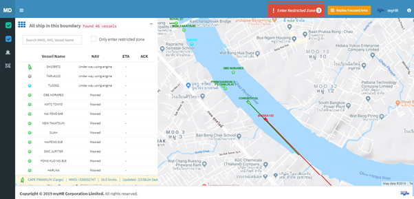
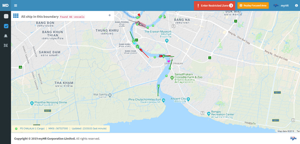
เครื่อง AIS เป็นระบบสอบถามและกระจายข่าวด้วยเทคโนโลยีพื้นฐานของ SOTDMA ( Self Organization Time Division Multiple Access ) ส่งกระจายสัญญาณภายใต้คลื่นวิทยุข่าย VHF Marine Band มีขีดความสามารถในการส่งข้อมูลต่าง ๆ ของเรือ เช่น ชื่อเรือ ตำแหน่งเรือปัจจุบัน เข็มเดินทาง ขนาดความยาวเรือ ความกว้างเรือ ประภทของเรือ กินน้ำลึก ข้อมูลของสินค้าอันตรายที่บรรทุกอยู่ โดยเครื่องGPS ของเรือจะทำการส่งค่าพิกัดตำบลที่ LAT/LONG รวมกับข้อมูลของเรือดังกล่าวจากเรือที่ติดตั้ง เครื่อง AIS ไปยังสถานีฝั่งหรือเรือที่อยู่ใกล้เคียง มีขีดความสามารถในการส่งข้อความได้มากถึง 1,000 ครั้งต่อ นาที และจะ update ข้อมูลตลอดเวลา โดยสามารถแสดงข้อมูล ที่รับได้บนเครื่องแผนที่อิเล็กทรอนิคส์ เช่น ECS หรือ ECDIS ได้ ภาพสัญลักษณ์นี้จะ บอกให้เรือทุกลำที่อยู่ในรัศมีของวิทยุ VHF ทราบตำบลที่และข้อมูลของเรือลำที่ติดตั้งเครื่อง AIS นั้นได้ตลอดเวลา สำหรับการติดตามและระมัดระวังมิให้เกิดอุบัติเหตุชนกัน หรือบอกข้อมูลเรือให้กับสถานีฝั่งที่ติดตั้งระบบ AIS หรือ VTS ใช้ในการควบคุมการสัญจรของเรือในร่องน้ำ หรือขณะเข้าออกจากท่าเทียบเรือ ซึ่งพื้นที่ครอบคลุมในการส่งสัญญาณของเครื่อง AIS ของเรือแต่ละลำจะอยู่ในรัศมีของระยะคลื่น VHF ขึ้น อยู่กับความสูงของเสาอากาศ โดยปกติจะมีรัศมีการทำงานประมาณ 20-25 ไมล์ทะเลจากเครื่อง AIS
(อ้างอิงจาก http://www.port.co.th/cs/internet/internetระบบ_AIS.html) ข้อมูลที่มีการรับ-ส่งในระบบ AIS ได้แก่
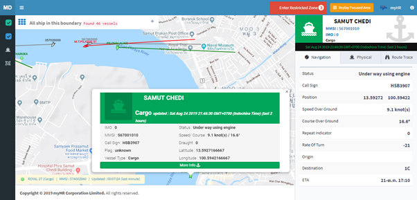
- หมายเลข IMO Number
- นามเรียกขานของเรือ
- ชื่อเรือ (Vessel Name)
- ชนิดของเรือ (Vessel Type)
- ขนาดของเรือ (Dimension)
- ตำแหน่งของเรือ (LAT/LONG) เวลาล่าสุด
- ทิศทางการเดินเรือ (Course)
- ความเร็วเรือ (Speed)
- อัตราการเลี้ยว (RoT – Rate of Turn)
- ทิศหัวเรือ (เข็มเรือจากเข็มทิศไยโร) (Heading)
- อัตราการกินน้ำลึกของเรือ (Draught)
- ชนิดของระวางสินค้า (Cargo Type)
- จุดหมายปลายทาง (Destination)
- วันเวลาที่จะเดินทางถึงจุดหมาย (ETA)

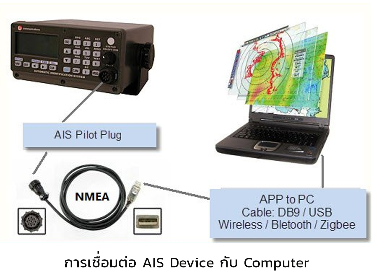
Example NMEA Data Transaction
“คราวนี้เรามาเข้าเรื่องของเรากันครับ”
- แจ้งเตือนเมื่อเรือใกล้จะชนกัน
- แจ้งเตือนเมื่อเรือเข้าไปในพื้นที่ที่มีไม่ควรไป
- แจ้งเตือนเมื่อเรือหายไปจากการติดตาม
- แจ้งเตือนเมื่อเรือวิ่งเร็วกว่าที่กำหนด
- แจ้งเตือนเมื่อเรือเข้ามาในพื้นที่ประเทศไทย
- แจ้งเตือนเมื่อเรือเข้าในพื้นที่ประเทศแต่ยังไม่ได้รับอนุญาต
- แจ้งเตือนเมื่อเรือที่ถูก Lock พังงาแล้วยังถูกใช้งาน
- แจ้งเตือนเมื่อเรือที่ถูกติดตามเป็นพิเศษเข้าในพื้นที่ที่กำหนด